Showing 1375 items matching aerial photographs
-
 Federation University Historical Collection
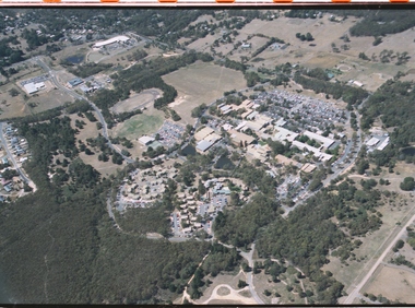
photographs and negatives, Aerial Photographs of Ballarat and Mount Helen, c1985
... Aerial Photographs of Ballarat and Mount Helen...aerial photographs... photographs and negatives Aerial Photographs of Ballarat and Mount ...Thirteen colour photographs and 47 negative strips of aerial views of Ballarat, Mt Helen and Mount Buninyongballarat, mount helen, buninyong, aerial photographs, student residences, bella guering residence, peter lalor residences, mount helen campus, camp street campus, arts academy, lake wendouree, ballarat cbd, ballarat school of mines, smb campus -
 Whitehorse Historical Society Inc.
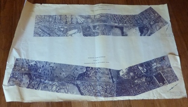
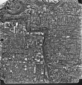
Map, Aerial Photographs Nunawading, 1970
... Aerial Photographs Nunawading...Aerial photographs... Mitcham melbourne Map Map Aerial Photographs Nunawading State ...State Aerial Survey, Melbourne 1970.State Aerial Survey, Melbourne 1970. Project runs 34 - 39 - City of Nunawading. Frames numbered from South to North boundaries, each strip numbered from East to West. See table of index and photo numbers attached.non-fictionState Aerial Survey, Melbourne 1970.state aerial survey, aerial photographs, nunawading, mitcham, blackburn, blackburn north, blackburn south, forest hill, vermont, burwood east, vermont south -
Whitehorse Historical Society Inc.
Map, Aerial photographs Nunawading, 1972
... Aerial photographs Nunawading...Aerial photographs... Mitcham melbourne Map Map Aerial photographs Nunawading Department ...Department of Crown Lands and Survey, Melbourne, 1972.Department of Crown Lands and Survey, Melbourne, 1972. Project runs 34 - 39 - City of Nunawading. frames numbered from South to North boundaries, each strip numbered from West to east. The series extends further West to Box Hill and East to Ringwood than the 1970 project. No index map. Sheets 39/2 and 34/28 missing.non-fictionDepartment of Crown Lands and Survey, Melbourne, 1972.victoria. department of crown lands and survey, aerial photographs, nunawading, mitcham, blackburn, blackburn north, blackburn south, forest hill, vermont, burwood east, box hill, ringwood, vermont south -
Whitehorse Historical Society Inc.
Map, Aerial photographs Nunawading, 1976
... Aerial photographs Nunawading...Aerial Photographs... Mitcham melbourne Map Map Aerial photographs Nunawading Department ...Department of Crown Lands and Survey, Melbourne, 1976 Project.Department of Crown Lands and Survey, Melbourne, 1976 Project. Runs 29 - 33 City of Nunawading. Frames numbered from South to North boundaries, each strip numbered from West to East. No index map. Sheets 30/8 and 30/9 missing.non-fictionDepartment of Crown Lands and Survey, Melbourne, 1976 Project. victoria. department of crown lands and survey, aerial photographs, nunawading, mitcham, blackburn, blackburn north, blackburn south, forest hill, vermont, vermont south, burwood east, box hill, ringwood -
 Melbourne Tram Museum
Drawing, Melbourne & Metropolitan Tramways Board (MMTB), Aerial photographs Bundoora Tram Extensions, Plenty Road – MMTB Drawings – 12/1979, Bundoora Extension – Metropolitan Transit Authority – 2/1983, John-Connell – Mott Hay and Anderson – Preliminary drawings for the Latrobe Modal Interchange – August 1984, 1979 to 1984
... Aerial photographs Bundoora Tram Extensions, Plenty Road... Interchange - 1984. Large print – Aerial photographs Bundoora Tram...On rear of aerial photograph sheet - at right hand end... Construction MTA On rear of aerial photograph sheet - at right hand end ...Set of drawings for the MMTB Plenty Road extension in 1979, MTA extension to Bundoora in 1983 and the Latrobe Uni Modal Interchange - 1984. Large print – Aerial photographs Bundoora Tram Extensions Stage 2 – Albert St to Kingsbury Drive Stage 3 – Kingsbury Drive to Settlement Road Has been rolled, left hand edge damaged, right hand edge torn Compiled by the ROW Division – 2/1981. Has written on rear at right hand end “Bundoora Tram Extension – Official MMTB Plans” 760H x 1190W Plenty Road – MMTB Drawings – 12/1979 P15123 Tyler St to Walsal Avenue P15124 Walsal Ave t McColl St P15125 McColl St to Dorrington Avenue Bundoora Extension – Metropolitan Transit Authority – 2/1983 P15400 Dorrington Avenue to Barwon Avenue P15401 Barwon Avenue to Nicholson Ave P15402 Nicholson St to Barling Park P15403 Barling Park to Darebin Creek P15404 Darebin Creek to Scott Grove P15405 Scott Grove to Clunes Street P15406 Clunes St to Cash St P15408 Cash St to Bundoora Park P15409 Bundoora Park to Larundel Hospital P15410 At Larundel Hospital P15411 Larundel Hospital to Marne Court P15412 Marne Court to Cherrywood Court P15413 Cherrywood Court to Morwell Ave P15414 Morwell Ave to Grimshaw St P15415 Grimshaw St to Nickson Street P15416 Nickson St to McLeans Road John-Connell – Mott Hay and Anderson – Preliminary drawings for the Latrobe Modal Interchange – August 1984. 8094-A-20 Set Out Plan and Paving Details 8094-A-21 Elevations 8094-A-22 Sections 8094-A-23 Roof Plan and Stormwater Layout 8094-A-24 Canopy Details 8094-A-25 Toilet Block and Waiting Room 8094-A-28 Miscellaneous DetailsOn rear of aerial photograph sheet - at right hand end “Bundoora Tram Extension – Official MMTB Plans” in felt pen.trams, tramways, plenty rd, bundoora, latrobe university, mmtb, construction, mta -
Stawell Historical Society Inc
Photograph, Stawell Aerial Photographs
... Stawell Aerial Photographs...3 Aerial photographs of Stawell possibly mining Surveys... grampians Photograph Stawell Aerial Photographs 3 Aerial photographs ...3 Aerial photographs of Stawell possibly mining Surveys for Stawell Gold MinesCoordinates -
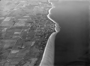
 Sunbury & District Heritage Association Inc
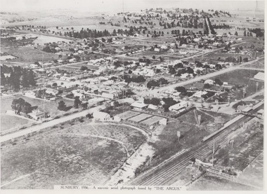
Photograph, 1936
... Aerial photographs...A black and white aerial photograph with a cream border...SUNBURY 1936 - A SOUVENIR AERIAL PHOTOGRAPH ISSUED... Photograph Photograph A black and white aerial photograph ...The aerial view of Sunbury was featured in The Argus newspaper in 1936 in recognition of 100 years of European settlement of the area. It shows the extent of the township in 1936 which extended from the railway line in the west to the Jackson Creek in the east and the Sunbury Asylum in the south and northwards towards Macedon Street. The photograph was taken when Sunbury was a country settlement 25 miles ( 37 kms) from Melbourne. Since the 1980s the area grown rapidly and is now an outer suburb of Melbourne.A black and white aerial photograph with a cream border of the Sunbury township. SUNBURY 1936 - A SOUVENIR AERIAL PHOTOGRAPH ISSUED BY THE ARGUS.aerial photographs -
 Phillip Island and District Historical Society Inc.
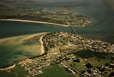
Photograph, Aerial photographs of Phillip Island, 1990s
... Aerial photographs of Phillip Island...Coloured photographs showing aerial views of the townships...-island-and-the-bass-coast Photograph Aerial photographs ...Coloured photographs showing aerial views of the townships and the Island.rhyll, photographs, cowes, san remo, newhaven, aerial views of phillip island -
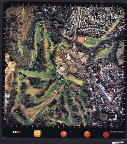
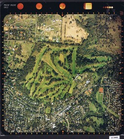 Heidelberg Golf Club
Photograph - Aerial Photograph, Heidelberg Golf Course 2000, 01/05/1980
... Aerial Photograph...Aerial photographs...Aerial photograph of Heidelberg Golf Club course in 1980...Aerial photograph, colour.... Photograph Photograph Heidelberg Golf Course 2000 Aerial photograph ...Aerial photograph of Heidelberg Golf Club course in 1980, showing the course layout and surrounding land use.Aerial photograph, colour.Printed on edge of photo: "Colour proof", "LandSur756"aerial photographs, heidelberg golf club, lower plenty -
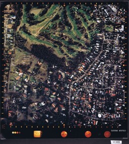 Heidelberg Golf Club
Photograph - Aerial Photograph, Heidelberg Golf Course 2000, 01/05/1980
... Aerial Photograph...Aerial photographs...Aerial photograph of Heidelberg Golf Club course in 1980...Aerial photograph, colour.... Photograph Photograph Heidelberg Golf Course 2000 Aerial photograph ...Aerial photograph of Heidelberg Golf Club course in 1980, showing layout of course and surrounding land use.Aerial photograph, colour.Printed on edge of photo: "Colour proof", "LandSur756"aerial photographs, heidelberg golf club, lower plenty -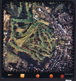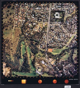
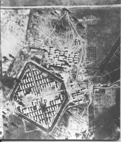 Tatura Irrigation & Wartime Camps Museum
Photograph, Aerial photo of camp 3 1946
... aerial photographs...Aerial photograph, taken in 1946 of the Rushworth...Black and white aerial photograph of camp 3 Rushworth...Photograph Photograph Aerial photo of camp 3 1946 Black ...Aerial photograph, taken in 1946 of the Rushworth internment camp.Black and white aerial photograph of camp 3 Rushworth showing layout of the camp.aerial photo of camp 3, taken in 1946, rushworth internment camp, aerial photographs, victorian internment camps -
4th/19th Prince of Wales's Light Horse Regiment Unit History Room
Aerial Photographs, Broadmeadows Victoria camp?, late 1940's
... Aerial Photographs...A set of 30 aerial photographs of what could... History Room Simpson Barracks Macleod melbourne Aerial Photographs ...A set of 30 aerial photographs of what could be Broadmeadows Victoria camp. Some show the terrain, others the camp layout and others of a tank regiment formed up in Squadrons. The majority of the tanks appear to be General Grantsairial photos, tank camp, broadmeadows -
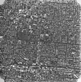 Kew Historical Society Inc
Photograph, Department of Property & Services (Victoria), City of Kew No.3/6, 12/12/1987
... aerial photograph - kew...One of a series of six small square black and white aerial...Aerial photograph of a part of Kew, taken by photographers... Photograph Photograph City of Kew No.3/6 Aerial photograph of a part ...One of a series of six small square black and white aerial photographs of Kew taken and produced by the Victorian Department of Property Services.Aerial photographs, of which the Society has a number in its collection, allow researchers to identify changes in urban infrastructure and demographics over timeAerial photograph of a part of Kew, taken by photographers employed by the Victorian Department of Property and Services in December 1987.aerial photograph - kew, aerial photographs -
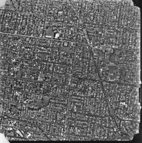 Kew Historical Society Inc
Photograph, Department of Property & Services (Victoria), City of Kew No.4/6, 12/12/1987
... aerial photograph - kew...One of a series of six small square black and white aerial...Aerial photograph of a part of Kew, taken by photographers... Photograph Photograph City of Kew No.4/6 Aerial photograph of a part ...One of a series of six small square black and white aerial photographs of Kew taken and produced by the Victorian Department of Property Services.Aerial photographs, of which the Society has a number in its collection, allow researchers to identify changes in urban infrastructure and demographics over timeAerial photograph of a part of Kew, taken by photographers employed by the Victorian Department of Property and Services in December 1987.aerial photograph - kew, aerial photographs -
 Kew Historical Society Inc
Photograph, Department of Property & Services (Victoria), City of Kew, No.5/6, 12/12/1987
... aerial photograph - kew...One of a series of six small square black and white aerial...Aerial photograph of a part of Kew, taken by photographers... Photograph Photograph City of Kew, No.5/6 Aerial photograph of a part ...One of a series of six small square black and white aerial photographs of Kew taken and produced by the Victorian Department of Property Services.Aerial photographs, of which the Society has a number in its collection, allow researchers to identify changes in urban infrastructure and demographics over timeAerial photograph of a part of Kew, taken by photographers employed by the Victorian Department of Property and Services in December 1987.aerial photograph - kew, aerial photographs -
 Kew Historical Society Inc
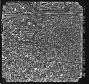
Photograph, Department of Property & Services (Victoria), City of Kew, No.6/6, 12/12/1987
... aerial photograph - kew...One of a series of six small square black and white aerial...Aerial photograph of a part of Kew, taken by photographers... Photograph Photograph City of Kew, No.6/6 Aerial photograph of a part ...One of a series of six small square black and white aerial photographs of Kew taken and produced by the Victorian Department of Property Services.Aerial photographs, of which the Society has a number in its collection, allow researchers to identify changes in urban infrastructure and demographics over timeAerial photograph of a part of Kew, taken by photographers employed by the Victorian Department of Property and Services in December 1987.4312-108 Ringwood M'Sheet 7922-3 Run 4 5600'ASL Vic DPS © 12-12-87aerial photograph - kew, aerial photographs -
 Bendigo Military Museum
Photograph - AERIAL PHOTOGRAPHS WW2, 1942 - 1944
... AERIAL PHOTOGRAPHS WW2...37 Aerial reconnaissance photographs of various locations... goldfields AERIAL PHOTOGRAPHS WW2 Photograph 37 Aerial reconnaissance ...Various reconnaissance photographs depicting targets in Timor for attack by the R.A.A.F. Items saved by Maurice Anthony BYRNE RAAF. Refer Cat No 215.9 for his service details.37 Aerial reconnaissance photographs of various locations over Timor and surrounding islands 1 Envelope: original container of photographs.Most images: Locations, including Latitude and Longitude marked on the backphotography-photographs-military, aerial -
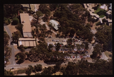
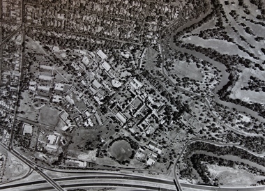
 Federation University Historical Collection
Photograph - Photorgraphs - Black and White, Aerial Photographs around the Ballarat School of Mines, Pre 1967
... Aerial Photographs around the Ballarat School of Mines...aerial photograph... Photorgraphs - Black and White Photograph Aerial Photographs around ...Ballarat School of Mines is in Lydiard Street South, in close proximity to White Flat oval. 3821.1 & .2 - Black and white photograph taken from an aeroplane over Ballarat. Shows Ballarat School of Mines, Ballarat Gaol, Ballarat Girls' Technical School, gasometers, White Flat, Yarrowee Channel. 8251.3 & .4 & .5 - Black and white photograph taken from an aeroplane over Ballarat. Shows Ballarat School of Mines, Ballarat Gaol, Ballarat Junior Technical School, Albert Street, Gaol garden, Manchester Unity Hall ballarat school of mines, aerial photograph, hickman street, white flat oval, former ballarat gaol, ballarat girls' technical school, gasometer, aeroplane, white flat, armstrong street south, ballarat gaol, manchester university hall -
 Federation University Historical Collection
Photograph - Colour, Aerial Photographs of the Federation University Mt Helen Campus
... Aerial Photographs of the Federation University Mt Helen... Photograph - Colour Aerial Photographs of the Federation University ...Seven colour photographs and a number of negative strips of the Mt Helen Campus, including student residences.mount helen, mount helen campus, federation university, student residences -
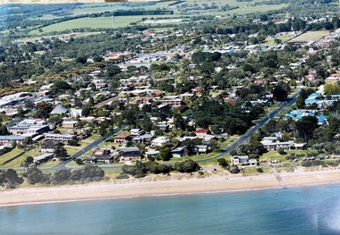
 Phillip Island and District Historical Society Inc.
Photograph, Historic aerial photographs of Phillip Island, Cowes, Rhyll, Cape Woolamai and San Remo, 1930s
... Historic aerial photographs of Phillip Island, Cowes, Rhyll...aerial photograph...-island-and-the-bass-coast Photograph Historic aerial photographs ...Photos taken by an unknown pioneer aviator researched by Kevin O'Reilly who has written a book "Flyers of Time" on pioneer aviation. Photos show the Island and San Remo prior to development and before the bridge was built from the mainland.HistoricalA C D Rom and USB of historic aerial photos about 1930s - 1940s of Phillip Island, Cowes, Rhyll, San Remo and Woolamai. Both formats contain the same 7 photos. Also a letter explaining the history of the photos.photographs, san remo, rhyll, cape woolamai, phillip island bridge, cowes, aerial photograph, digital media, residential development, newhaven -
 Phillip Island and District Historical Society Inc.
Photograph, Aerial photographs of Phillip Island and letter from Joshua Gliddon to June Gould
... Aerial photographs of Phillip Island and letter from Joshua...aerial photograph...-island-and-the-bass-coast Photograph Aerial photographs ...Joshua Gliddon wrote Phillip Island in Picture and Story which is referred to in the letter. The McHaffie family were original settlers on the Island. Historical3 large coloured aerial photos of Cowes and San Remo and a letter from Joshua Gliddon to June Gould re the McHaffie propertycoloured photograph, aerial photograph, joshua gliddon, mchaffie family, sambell family, cowes, san remo, cowes yacht club, phillip island in picture and story, june gould -
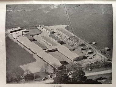 Ballarat Heritage Services
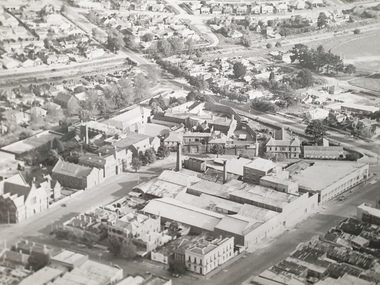
Photograph - Black and White, Ballarat East High School, aerial photographs
... Ballarat East High School, aerial photographs... School, aerial photographs Three black and white photographs ...Three black and white photographs of the Ballarat East High School. ballarat east high school, education -
 Kew Historical Society Inc
Photograph - Aerial Photograph, Aerial Photograph of Willsmere, circa 1980, c. 1980
... Aerial Photograph...Aerial Photograph of Willsmere, circa 1980...aerial photographs -- kew (vic)...This aerial photograph shows the Kew Cottages, and doctors...Aerial photograph of Willsmere and the Kew Cottages bounded... Aerial Photograph Photograph Aerial Photograph of Willsmere ...This aerial photograph shows the Kew Cottages, and doctors/clergy residences on the north side of Wills Street, before the State Government sold the land for residential development. The doctors residences in Wills street were made of 'Glen Iris' Olympic Bricks. According to neighbours of the time most of the buildings were demolished overnight in the 1980s.Aerial photograph of Willsmere and the Kew Cottages bounded by the Boulevard, the Chandler Highway, Princess Street and Fellows Street. The roundabout at the intersection of Princess Street, Wills Street, and Eglinton Street is at the top left. The Eastern Freeway is at the lower edge of the photograph.kew cottages, eastern freeway, willsmere, yarra river, aerial photographs -- kew (vic), kew boulevard, willsmere mental hospital, kew mental hospital, kew childrens cottages -
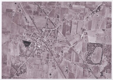 Rutherglen Historical Society
Map - Photocopy of an aerial photograph
... Photocopy of an aerial photograph...aerial photographs...Photocopy of an aerial photograph of Rutherglen...-country Photocopy of an aerial photograph Map Photocopy ...Photocopy of an aerial photograph of Rutherglenaerial photographs, rutherglen -
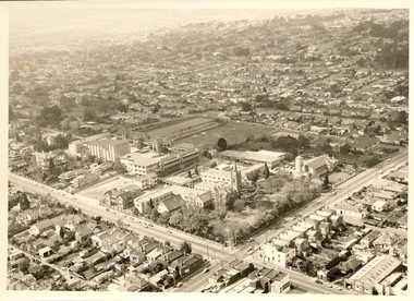 Kew Historical Society Inc
Photograph - Digital Image, Methodist Ladies' College Hawthorn from the Air, 2020
... aerial photographs...Aerial photograph of Methodist Ladies' College, Hawthorn.... the Air Aerial photograph of Methodist Ladies' College, Hawthorn ...Digital image of MLC Kew from a photograph album belonging to Judith Scurfield.Aerial photograph of Methodist Ladies' College, Hawthorn.methodist ladies' college - kew (vic), aerial photographs -
Whitehorse Historical Society Inc.
Map, Blackburn Lake, 1960s
... Aerial photographs...Aerial photograph of Blackburn Lake Sanctuary 1960s.... Mitcham melbourne Map Map Blackburn Lake Aerial photograph ...Aerial photograph of Blackburn Lake Sanctuary 1960s.Aerial photograph of Blackburn Lake Sanctuary 1960s.Aerial photograph of Blackburn Lake Sanctuary 1960s.aerial photographs, blackburn lake sanctuary -
Whitehorse Historical Society Inc.
Map, Blackburn Lake, c1968
... Aerial photographs...Enlarged aerial photograph of Blackburn Lake area.... Aerial photographs Enlarged aerial photograph of Blackburn Lake ...Enlarged aerial photograph of Blackburn Lake area.Enlarged aerial photograph of Blackburn Lake area.Enlarged aerial photograph of Blackburn Lake area.blackburn lake sanctuary, adult deaf & dumb home, lake road, blackburn, central road, blackburn, aerial photographs